What Happens When Air Masses Collide
Juapaving
Mar 23, 2025 · 7 min read
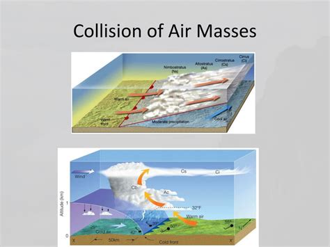
Table of Contents
What Happens When Air Masses Collide? A Deep Dive into Frontal Systems
The Earth's atmosphere is a dynamic and ever-changing system, driven by the unequal heating of the planet's surface. This heating creates vast bodies of air with distinct temperature and moisture characteristics, known as air masses. When these air masses collide, they don't simply mix; instead, they interact in complex ways, giving rise to a variety of weather phenomena, from gentle breezes to violent storms. Understanding these interactions is crucial for predicting weather patterns and mitigating their potential impacts.
The Nature of Air Masses
Before diving into the collisions, let's establish a firm understanding of what constitutes an air mass. Air masses are large bodies of air, typically hundreds or even thousands of kilometers across, that are relatively homogeneous in temperature and humidity. They acquire their characteristics from the surface over which they form, a process known as source region.
Characteristics Defining Air Masses:
- Temperature: Air masses are classified as arctic, polar, tropical, or equatorial based on their temperature. Arctic air is the coldest, followed by polar, tropical, and then equatorial.
- Moisture: The moisture content is determined by the source region. Air masses forming over oceans (maritime) are typically moist, while those forming over continents (continental) are drier.
- Stability: The stability of an air mass refers to its tendency to rise or sink. Stable air tends to resist vertical motion, while unstable air readily rises, leading to cloud formation and precipitation.
These characteristics are often combined to create descriptive labels for air masses. For instance, a continental polar air mass (cP) is cold and dry, while a maritime tropical air mass (mT) is warm and moist.
Types of Fronts: Where Air Masses Meet
The boundary between two different air masses is called a front. Fronts are not simply lines on a map; they are zones of transition where the characteristics of the two air masses interact. The type of front that forms depends on the relative motion of the colliding air masses.
1. Cold Fronts: A Rapid Push
A cold front occurs when a colder, denser air mass advances and pushes under a warmer, less dense air mass. This process is relatively rapid, often resulting in:
- Steep slopes: The leading edge of the cold air mass forces the warm air upward rapidly, creating a steep frontal slope.
- Intense uplift: This rapid uplift leads to significant condensation and cloud development, often producing towering cumulonimbus clouds.
- Severe weather: Cold fronts are frequently associated with thunderstorms, heavy rainfall, strong winds, hail, and even tornadoes, particularly along the squall line ahead of the advancing front.
- Narrow band of precipitation: Precipitation is typically concentrated along a relatively narrow band just ahead of the front.
- Temperature drop: After the passage of a cold front, a significant drop in temperature is experienced.
- Pressure changes: A cold front passage is often accompanied by a rapid increase in atmospheric pressure.
Understanding Cold Front Symbols: On weather maps, cold fronts are represented by a line with triangles pointing in the direction of the front's movement.
2. Warm Fronts: A Gradual Rise
A warm front occurs when a warmer, less dense air mass overruns a colder, denser air mass. This process is more gradual than a cold front, resulting in:
- Gentle slopes: The warmer air rises more slowly over the colder air, creating a gentler frontal slope.
- Widespread cloud cover: This slow ascent leads to the formation of widespread stratiform clouds, such as altostratus and nimbostratus.
- Steady precipitation: Warm fronts are often associated with prolonged periods of light to moderate rain or snow.
- Gradual temperature rise: After the passage of a warm front, a gradual increase in temperature is observed.
- Pressure changes: Warm fronts typically exhibit a gradual decrease in atmospheric pressure before the front passes.
Understanding Warm Front Symbols: On weather maps, warm fronts are represented by a line with semicircles pointing in the direction of the front's movement.
3. Stationary Fronts: A Stalemate
A stationary front occurs when two air masses meet but neither has enough force to advance over the other. This results in a prolonged period of unsettled weather, with:
- Prolonged cloud cover and precipitation: Similar to warm fronts, stationary fronts can bring extended periods of cloud cover and precipitation.
- Slow movement or no movement: The front remains relatively stationary or moves very slowly.
- Persistent weather conditions: The weather conditions remain largely unchanged for several days.
Understanding Stationary Front Symbols: On weather maps, stationary fronts are represented by a line with alternating triangles and semicircles pointing in opposite directions.
4. Occluded Fronts: A Complex Interaction
An occluded front forms when a faster-moving cold front catches up to and overtakes a slower-moving warm front. This results in a complex interaction, with three air masses involved:
- Warm air aloft: The warm air mass initially between the cold and warm fronts is lifted aloft.
- Cold air underneath: The colder, denser air mass of the advancing cold front pushes under both the warm and the cooler air mass ahead of it.
- Variety of weather: Occluded fronts can produce a variety of weather conditions, depending on the temperatures of the colliding air masses. They can bring periods of rain, snow, and strong winds.
Understanding Occluded Front Symbols: On weather maps, occluded fronts are represented by a line with alternating triangles and semicircles on the same side, indicating the type of air mass being overtaken.
Beyond the Basics: Secondary Effects of Air Mass Collisions
The collision of air masses and the resulting frontal systems don't just produce precipitation and temperature changes; they also trigger a range of secondary effects that significantly influence weather patterns:
- Jet Streams: The interaction of air masses plays a crucial role in shaping the paths and intensities of jet streams, high-altitude rivers of fast-flowing air. Changes in the position and strength of jet streams can dramatically affect weather systems at lower altitudes.
- Cyclogenesis: The collision of air masses is a major factor in cyclogenesis, the formation of cyclones (low-pressure systems). The interaction of contrasting air masses can create instability, triggering the development of cyclonic circulation.
- Mesoscale Convective Systems (MCSs): These large, long-lived thunderstorm complexes are often generated along frontal boundaries, particularly along cold fronts. MCSs can produce widespread heavy rain, damaging winds, and even tornadoes.
- Severe Weather Events: The most extreme weather events, such as hurricanes, blizzards, and derechos, are often linked to the complex interactions of air masses at various scales.
Predicting Air Mass Collisions and their Impacts
Accurate prediction of air mass collisions and their resulting weather effects relies on sophisticated weather models that incorporate various data sources, including:
- Satellite imagery: Provides a broad view of cloud cover and frontal systems.
- Radar data: Tracks precipitation intensity and movement.
- Surface observations: Provides information on temperature, humidity, wind speed, and pressure.
- Upper-air observations: Provides data on atmospheric conditions at various altitudes.
These data are fed into complex computer models that simulate atmospheric processes and predict future weather conditions. The accuracy of these predictions depends on the quality and resolution of the data, as well as the sophistication of the models. Despite advancements in forecasting technology, predicting the exact timing and intensity of severe weather events associated with air mass collisions remains a challenge.
Conclusion: A Complex Dance of Atmospheric Dynamics
The interaction of air masses is a fundamental process driving the Earth's weather systems. The collisions of these large bodies of air, leading to the formation of various frontal systems, result in a wide spectrum of weather phenomena, from gentle rain showers to devastating storms. Understanding the dynamics of these interactions is not merely an academic pursuit; it's crucial for protecting lives and property through accurate weather forecasting and effective disaster preparedness. As our understanding of atmospheric dynamics continues to improve, so too will our ability to predict and respond to the challenges posed by these powerful forces of nature. Continued research and technological advancements remain key to enhancing our predictive capabilities and mitigating the impacts of air mass collisions on our world.
Latest Posts
Latest Posts
-
Examples Of Newtons Second Law Of Motion In Everyday Life
Mar 24, 2025
-
Write 84 As A Product Of Prime Factors
Mar 24, 2025
-
Compute The Value Of The Discriminant
Mar 24, 2025
-
What Is The Main Cause Of Non Ideality In Gases
Mar 24, 2025
-
Is Air A Compound Mixture Or Element
Mar 24, 2025
Related Post
Thank you for visiting our website which covers about What Happens When Air Masses Collide . We hope the information provided has been useful to you. Feel free to contact us if you have any questions or need further assistance. See you next time and don't miss to bookmark.
