When Two Air Masses Meet What Happens
Juapaving
Apr 01, 2025 · 6 min read
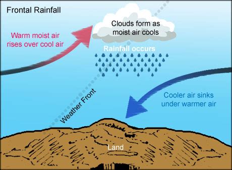
Table of Contents
When Two Air Masses Meet: A Deep Dive into Frontal Systems
When two air masses collide, the atmosphere doesn't simply blend them together like mixing paint. Instead, a dynamic and often dramatic process unfolds, shaping weather patterns across the globe. Understanding what happens when these massive bodies of air meet is crucial to comprehending weather forecasting and the powerful forces that drive our climate. This article will explore the fascinating world of frontal systems, delving into the different types of fronts, their associated weather phenomena, and the broader implications for our understanding of atmospheric dynamics.
Understanding Air Masses: The Building Blocks of Weather
Before diving into the interactions, it's crucial to grasp the concept of air masses themselves. An air mass is a large body of air with relatively uniform temperature and humidity characteristics. These characteristics are largely determined by the surface over which the air mass forms. For example, an air mass originating over a vast, cold continental landmass will be cold and dry, while one forming over a warm ocean will be warm and moist. This fundamental difference in properties is what fuels the dramatic weather associated with air mass collisions.
Key Characteristics Defining Air Masses:
- Temperature: This dictates the air mass's thermal stability, influencing whether it rises (unstable) or sinks (stable).
- Humidity: This refers to the amount of water vapor present, determining the air mass's potential for cloud and precipitation formation.
- Source Region: The geographic origin of the air mass fundamentally shapes its properties. Arctic, Polar, Tropical, and Equatorial air masses all possess distinct traits.
The Collision Course: When Air Masses Meet
The boundary between two different air masses is called a front. The interaction at this boundary is anything but passive. Because air masses have different densities (warmer, moister air is less dense than colder, drier air), they don't readily mix. Instead, they interact in distinct ways, leading to the formation of different types of fronts, each with its unique weather characteristics.
Types of Fronts: A Closer Look
There are four main types of fronts: cold fronts, warm fronts, stationary fronts, and occluded fronts. Each exhibits different characteristics and produces distinct weather patterns.
1. Cold Fronts: Rapid Advancement and Intense Weather
A cold front occurs when a colder, denser air mass actively pushes into a region of warmer, less dense air. This is a relatively fast-moving process, often leading to dramatic weather changes. As the cold, denser air wedges under the warmer air, it forces the warmer air to rise rapidly. This rapid uplift leads to:
- Cumulonimbus cloud development: These towering clouds are associated with intense thunderstorms, heavy rain, hail, strong winds, and even tornadoes.
- Narrow band of precipitation: The precipitation is typically concentrated along the frontal boundary.
- Sharp temperature drop: After the cold front passes, a significant drop in temperature is experienced.
- Shifting wind direction: Wind direction often shifts dramatically after the front passes, typically becoming westerly or northwesterly in the mid-latitudes.
2. Warm Fronts: Gradual Ascent and Widespread Precipitation
A warm front is characterized by the gradual advance of warmer, less dense air over a colder, denser air mass. This process is significantly slower than the advance of a cold front. The warmer air gradually rises over the retreating wedge of cold air, leading to:
- Stratiform cloud development: These layered clouds produce widespread, lighter precipitation, often in the form of drizzle or light to moderate rain.
- Gradual temperature rise: The temperature rises slowly as the warm front passes.
- Increased humidity: The air becomes increasingly humid and muggy ahead of the warm front.
- Reduced visibility: Fog and low clouds can reduce visibility significantly.
3. Stationary Fronts: A Standoff of Air Masses
A stationary front occurs when there is little to no movement between two air masses. The boundary between them remains relatively stationary for an extended period. This can lead to prolonged periods of cloudy weather and precipitation, particularly along the frontal zone. The type of precipitation will depend on the characteristics of the air masses involved. Stationary fronts can persist for days or even weeks, until a shift in atmospheric pressure gradients leads to their movement.
4. Occluded Fronts: A Complex Interaction
An occluded front forms when a faster-moving cold front catches up to and overtakes a slower-moving warm front. This process leads to a complex interaction where the warmer air mass is lifted aloft, often resulting in a mixture of weather characteristics. The type of occlusion (cold-type or warm-type) depends on the relative temperatures of the two colliding cold air masses. Occluded fronts can produce a variety of weather, including precipitation, cloudiness, and changes in temperature and wind.
Beyond the Basics: Secondary Features and Associated Weather
The interactions at frontal boundaries are complex and often involve secondary features that further influence weather patterns.
Squall Lines: Lines of Intense Thunderstorms
These are elongated bands of thunderstorms that develop along or ahead of a cold front. They are associated with intense and often widespread severe weather, including strong winds, heavy rain, hail, and tornadoes.
Mesocyclones: Rotating Thunderstorms
These are rotating updrafts within thunderstorms, often associated with the formation of tornadoes. Their development is highly dependent on atmospheric instability and wind shear.
Drylines: Boundaries of Humidity Differences
These boundaries separate moist air from dry air. They are often associated with the development of severe thunderstorms in the Great Plains of the United States. The contrast in moisture content leads to strong lifting and instability.
Forecasting Frontal Systems: A Critical Role in Meteorology
Understanding frontal systems is paramount to accurate weather forecasting. Meteorologists use sophisticated models and data from weather stations, satellites, and radar to track the movement and evolution of fronts. By analyzing these data, they can predict the timing, intensity, and location of associated weather events, providing crucial information for public safety and preparedness. The ability to accurately predict the movement and associated weather is critical for mitigating risks associated with severe weather events.
The Broader Context: Frontal Systems and Climate
Frontal systems play a crucial role in the global distribution of heat and moisture. They are major players in regulating climate patterns and influencing regional weather conditions. The frequency and intensity of frontal passages can vary considerably depending on geographical location and season. Understanding the dynamics of these systems helps us understand the interplay between weather and climate on both local and global scales.
Conclusion: A Dynamic Dance of Air Masses
When two air masses meet, the consequences are far from subtle. The resulting frontal systems are dynamic processes that shape weather patterns across the globe. By understanding the different types of fronts, their associated weather phenomena, and the complex interactions at the boundaries, we gain invaluable insight into the forces that drive our weather and climate. This knowledge is critical not only for weather forecasting and understanding our environment but also for preparing for and mitigating the impacts of severe weather events. The ongoing study and refinement of atmospheric modeling continues to enhance our understanding of these powerful atmospheric phenomena, ultimately contributing to more accurate forecasts and improved public safety. The collision of air masses is a constant reminder of the dynamic and ever-changing nature of our planet's atmosphere.
Latest Posts
Latest Posts
-
What Is Bigger 1 2 Or 3 8
Apr 02, 2025
-
Least Common Multiple Of 20 And 30
Apr 02, 2025
-
Difference Between Starch Cellulose And Glycogen
Apr 02, 2025
-
What Is The Primary Function Of The Excretory System
Apr 02, 2025
-
How To Write 1300 On A Check
Apr 02, 2025
Related Post
Thank you for visiting our website which covers about When Two Air Masses Meet What Happens . We hope the information provided has been useful to you. Feel free to contact us if you have any questions or need further assistance. See you next time and don't miss to bookmark.
