What Mountain Range Separates Europe And Asia
Juapaving
Mar 09, 2025 · 5 min read
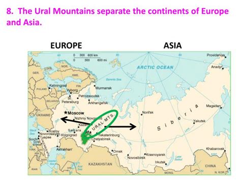
Table of Contents
What Mountain Range Separates Europe and Asia? The Ural Mountains and More
The question of what mountain range separates Europe and Asia is deceptively simple. While the Ural Mountains are often cited as the primary divider, the truth is far more nuanced and geographically complex. There's no single, universally agreed-upon boundary, and the division is more of a gradual transition than a sharp line drawn on a map. This article delves into the complexities of the Europe-Asia boundary, exploring the Ural Mountains' role, examining alternative demarcations, and considering the geographical, historical, and cultural factors that complicate this seemingly straightforward question.
The Ural Mountains: A Major, But Not Sole, Dividing Line
The Ural Mountains, stretching roughly 2,500 kilometers (1,550 miles) from the Arctic Ocean to the Kazakh steppes, are undeniably a significant geographical feature commonly used to delineate the border between Europe and Asia. Their imposing presence and relatively clear geological definition have made them a convenient, if imperfect, marker.
Geological Significance of the Urals
Geologically, the Urals represent a distinct ancient mountain range, formed during the Paleozoic Era, making them significantly older than the Himalayas or the Alps. Their formation resulted from the collision of the East European and Siberian cratons, leaving behind a rich tapestry of mineral deposits, contributing to their historical significance in mining and industrial development. This geological distinctness further reinforces their role as a plausible boundary marker.
Limitations of the Ural Mountain Boundary
Despite their geological prominence, relying solely on the Urals to define the Europe-Asia boundary presents limitations. The range's relatively narrow width, especially in certain sections, means the division can be arbitrary. Moreover, the foothills and plains extending from the Urals blur the line, making a precise delineation challenging. It's not a sharp, definitive wall but a gradual transition.
Beyond the Urals: Other Geographic Markers of the Boundary
While the Ural Mountains serve as a prominent landmark, other geographical features are often invoked to refine or supplement the boundary definition. These include:
The Ural River: A Watery Border
The Ural River, originating in the Ural Mountains, flows south towards the Caspian Sea. Its course, while not directly following the mountain range, often serves as a natural continuation of the boundary line, providing a watery extension of the continental divide. However, even the river's path doesn't offer a universally accepted solution, as its course doesn't precisely follow a clear continental separation.
The Caucasus Mountains: A Region of Complex Boundaries
The Caucasus Mountains, located south of the Russian plains, pose a significant challenge to the simple Ural-based delineation. This imposing mountain range is home to a diverse array of cultures and nations, with its foothills and plains sprawling across multiple geopolitical entities. Some geographers suggest extending the boundary through the Caucasus, though doing so requires making complex decisions about which side specific countries fall on – some include both European and Asian territories.
The Kuma-Manych Depression: A Low-Lying Boundary
The Kuma-Manych Depression, a low-lying valley extending from the Sea of Azov to the Caspian Sea, represents another potential boundary marker. This relatively flat region provides a subtle contrast to the rugged terrain of the surrounding mountains and plains. However, its inclusion in the Europe-Asia delineation is far from universally accepted and largely hinges on geopolitical and historical arguments, rather than distinct geographical separation.
The Role of Political and Historical Factors
The Europe-Asia boundary is not solely a matter of geography; political and historical factors heavily influence its definition. National borders, historical empires, and cultural affiliations all play a role in shaping our understanding of this continental divide.
Shifting Political Landscapes and Borders
The political landscape of Eurasia has shifted dramatically throughout history. The collapse of the Soviet Union, for instance, dramatically altered the perception and influence of the Ural Mountains' importance as a border marker. Newly independent states have different perspectives and priorities in how they view their positioning relative to the traditionally defined boundary.
Cultural Influences on Defining Continents
Cultural influences significantly impact how continents are perceived. The historical and cultural ties between nations on either side of the proposed borders often overshadow purely geographical considerations. Regions may identify more strongly with one continent over another, regardless of their physical location relative to the traditional boundary.
The Evolving Nature of Defining Continents
The concept of clearly defined continents is itself a relatively recent development, shaped by cartographic conventions and evolving geopolitical realities. The lines drawn on maps, even those appearing definitive, often represent simplifications of complex geographic and cultural transitions.
Conclusion: A Blurred Line, Not a Clear Divide
In conclusion, the question "What mountain range separates Europe and Asia?" doesn't have a single definitive answer. While the Ural Mountains serve as a primary and widely accepted geographical marker, the boundary is far more intricate than a simple mountain range. The Ural River, the Caucasus Mountains, and the Kuma-Manych Depression further complicate the issue, highlighting the interplay of geographical, historical, political, and even cultural factors. The Europe-Asia divide is best understood not as a sharp line but as a gradual and complex transition across a wide expanse of land, a fluid boundary shaped by human history and interpretations as much as by the Earth’s physical formations. The lack of a concrete universally agreed upon definition makes for a fascinating and ongoing discussion, demonstrating the intricacy and ambiguity that can lie within seemingly simple geographical questions.
Latest Posts
Latest Posts
-
Which Of The Following Is Not
Mar 10, 2025
-
250 Square Meters To Square Feet
Mar 10, 2025
-
How Many Millimeters Are In One Meter
Mar 10, 2025
-
How Many Milliseconds Are In A Minute
Mar 10, 2025
-
How Many Valence Electrons Does Copper Have
Mar 10, 2025
Related Post
Thank you for visiting our website which covers about What Mountain Range Separates Europe And Asia . We hope the information provided has been useful to you. Feel free to contact us if you have any questions or need further assistance. See you next time and don't miss to bookmark.
