What Happens When Two Air Masses Meet
Juapaving
Mar 12, 2025 · 6 min read
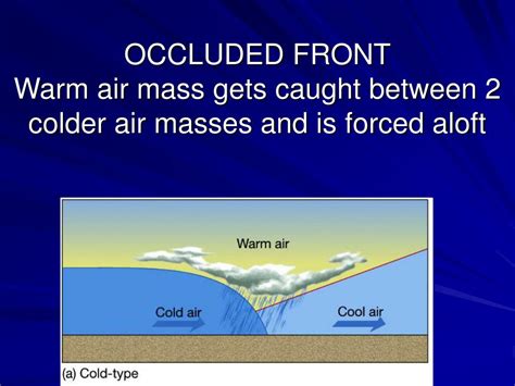
Table of Contents
What Happens When Two Air Masses Meet? A Deep Dive into Fronts and Weather Systems
The Earth's atmosphere is a dynamic system, constantly in motion. A significant driver of this motion is the interaction of different air masses. Air masses are large bodies of air with relatively uniform temperature and humidity characteristics. When two air masses with differing properties collide, a fascinating interplay of forces unfolds, leading to the formation of weather fronts and a wide range of weather phenomena. Understanding these interactions is crucial to comprehending and predicting weather patterns globally.
Understanding Air Masses: The Building Blocks of Weather
Before diving into the collision, it's essential to understand the characteristics of air masses themselves. They are classified based on their source region and the temperature of the surface over which they form. Common classifications include:
-
Polar (P): These air masses originate in high-latitude regions, characterized by cold temperatures. They can be further categorized as maritime polar (mP) – moist and relatively mild – or continental polar (cP) – dry and very cold.
-
Tropical (T): Originating in low-latitude regions near the equator, these air masses are warm. Again, a distinction is made between maritime tropical (mT) – warm and humid – and continental tropical (cT) – hot and dry.
-
Arctic (A): These are extremely cold and dry air masses forming over the Arctic regions.
-
Equatorial (E): These are warm and humid air masses originating near the equator.
The temperature and moisture content of these air masses are crucial in determining the type of weather produced when they interact.
The Collision: Where Fronts are Born
The boundary zone where two air masses of different densities converge is called a front. The density difference is primarily due to variations in temperature. Colder air is denser and tends to underlie warmer air, creating a sloping surface of contact. The type of front formed depends on the relative motion of the air masses.
1. Cold Fronts: A Rapid Push of Cold Air
A cold front occurs when a cold air mass actively pushes into and under a warmer air mass. This process is relatively fast, often moving at speeds of 20-40 mph (30-65 km/h). The leading edge of the cold air is steep, forcing the warmer, less dense air upwards rapidly. This rapid uplift leads to:
-
Cumulonimbus cloud development: The forced ascent of warm, moist air causes rapid condensation, leading to towering cumulonimbus clouds. These clouds are associated with severe thunderstorms, heavy rain, hail, strong winds, and even tornadoes.
-
Narrow band of precipitation: The precipitation associated with cold fronts is typically concentrated in a relatively narrow band along the front itself.
-
Temperature drop: After the passage of a cold front, a significant temperature drop is observed, often accompanied by a shift in wind direction. The air becomes drier and clearer.
-
Squall lines: In some cases, especially with strong cold fronts, a line of severe thunderstorms, known as a squall line, can develop ahead of the front.
2. Warm Fronts: A Gradual Advance of Warm Air
A warm front forms when a warm air mass gradually overruns a cooler air mass. Unlike cold fronts, this process is slower, often moving at speeds of 10-20 mph (15-30 km/h). The slope of the warm front is gentler, leading to a more gradual uplift of the cooler air. This results in:
-
Stratiform cloud development: The slow uplift produces layered, stratiform clouds, such as cirrus, altostratus, and nimbostratus.
-
Widespread precipitation: Warm fronts are associated with widespread, but generally lighter, precipitation, often lasting for many hours. The precipitation is usually more steady and less intense than that associated with cold fronts.
-
Gradual temperature rise: After the passage of a warm front, a gradual increase in temperature is observed, along with an increase in humidity.
-
Fog formation: In some cases, fog can form along or behind the warm front due to the saturation of the air.
3. Stationary Fronts: A Stalemate of Air Masses
A stationary front occurs when the boundary between two air masses remains essentially stationary for an extended period. Neither air mass is strong enough to push the other significantly. This results in prolonged periods of:
-
Cloudy skies: The boundary zone is characterized by persistent cloud cover, often with periods of drizzle or light rain or snow.
-
Gentle breezes: Wind speeds are usually relatively light along a stationary front.
-
Potential for severe weather: While generally less intense than cold fronts, stationary fronts can still produce periods of moderate to heavy precipitation, especially if a low-pressure system becomes associated with them. They can also linger for extended periods, causing prolonged periods of unsettled weather.
4. Occluded Fronts: A Complex Interaction
An occluded front forms when a faster-moving cold front catches up to and overtakes a slower-moving warm front. This creates a complex situation where the warm air mass is lifted completely off the ground, resulting in:
-
Mixture of cold and warm air characteristics: The weather associated with occluded fronts is a mix of characteristics of both warm and cold fronts. They can produce moderate to heavy precipitation, along with changes in temperature and wind direction.
-
Different types of occlusions: Occluded fronts can be either warm-type or cold-type, depending on whether the colder air behind the occluded front is colder or warmer than the air ahead of the warm front. This influences the intensity and type of precipitation.
Beyond Fronts: Other Weather Phenomena Driven by Air Mass Interactions
Air mass interactions are not solely responsible for the formation of fronts. They play a critical role in other significant weather phenomena:
-
Cyclogenesis: The development of low-pressure systems (cyclones) often involves the interaction of different air masses, particularly at the convergence zones of fronts. These cyclones can lead to widespread precipitation and strong winds.
-
Thunderstorms: While often associated with cold fronts, thunderstorms can also develop at other boundaries where there’s significant uplift of moist air. The instability generated by the meeting of differing air masses is a key ingredient in thunderstorm formation.
-
Tornadoes: These violent rotating columns of air are usually associated with severe thunderstorms, often those developing along cold fronts. The contrasting properties of the air masses contribute to the intense atmospheric instability that fuels tornado development.
-
Hurricanes: While the exact mechanisms of hurricane formation are complex, the interplay of warm, moist air masses over tropical oceans and surrounding drier air masses plays a significant role in their development and intensification.
Predicting the Weather: The Importance of Air Mass Analysis
Meteorologists use sophisticated models and observations to predict the interactions of air masses and the resulting weather. Analysis of weather maps showing air mass boundaries (fronts), pressure systems, and atmospheric conditions is crucial in making accurate forecasts. Understanding the characteristics of each air mass, their relative movement, and the resulting frontal systems allows for prediction of precipitation, temperature changes, wind speeds, and the potential for severe weather.
Conclusion: A Dynamic Dance of Air
The interaction of air masses is a fundamental process governing weather patterns across the globe. From the gentle rain of a warm front to the fierce storms of a cold front, the meeting of these gigantic atmospheric entities shapes our climate and daily experience. By understanding the dynamics of air mass collisions, we gain a deeper appreciation of the complexity and beauty of the Earth’s atmosphere and can improve our ability to predict and prepare for the ever-changing weather around us. Further research into the intricacies of these interactions continues to refine our understanding and enhance the accuracy of weather forecasting, leading to improved safety and preparedness for communities worldwide.
Latest Posts
Latest Posts
-
1 2 Or 3 8 Which Is Bigger
Mar 12, 2025
-
Whats The Square Root Of 112
Mar 12, 2025
-
Martin Puts Two Bowls Of Fruit Out For His Friends
Mar 12, 2025
-
How Many Centimeters Is 30 Inches
Mar 12, 2025
-
How Many Zeros In One Crore
Mar 12, 2025
Related Post
Thank you for visiting our website which covers about What Happens When Two Air Masses Meet . We hope the information provided has been useful to you. Feel free to contact us if you have any questions or need further assistance. See you next time and don't miss to bookmark.
